
Libramont (BE)
 Category Town planning and architecture
Location Libramont-Chevigny, Train station quarter
Population 10,947 inhab.
Strategic site c. 32 ha - Project site 10 ha
Site proposed by Municipality of Libramont and Belgian Rail (SNCB)
Owner(s) of the site mostly SNCB, the Municipality and private individuals
Commision after competition Town planning study, architectural design of public spaces and certain buildings
Team representative town planner – landscape architect – architect
More info
How can the site contribute to the adaptable city?
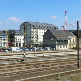
In the heart of the province of Luxembourg, the municipality of Libramont-Chevigny is situated on the high plateau of the Belgian Ardennes. A simple hamlet up to the 19th century, the village of Libramont would grow after the arrival of the railway. The focal point of a rural region, Libramont boasts several public facilities: schools, hospital, cultural centre, exhibition centre, convention centre. Its development has in recent decades shifted to the Recogne commercial hub, situated 1.5 km from the centre. Today, a new development dynamism is gradually taking shape in the train station quarter. The upcoming release of all rail operation for part of the land in the South West of the railway lines constitutes a winning asset for the development of the centre of Libramont. The Municipality accordingly wants a master plan covering the entire area.
City strategy
Thanks to its “railway boom,” Libramont developed on either side of the railway line. The quarter of the centre to the South-West of the railway lines comprises many public buildings around the Place Communale. The North-south bank of the railway plays host to the intermodal hub and public facilities. The cut-off formed by the railway lines is crossed only at two points. The municipality wants to restructure two banks on either side of the train station and to link them so as to create the Heart of Libramont. This response to the needs to do with demographics, commerce and business facilities should boost the appeal of the train station and develop the administrative role of Libramont. Three lines of action have been determined: improve the functionality of the train station to turn it into a 21st century station, give new impetus to the forecourt of the train station by making it denser and connecting the quarters on either side of the railway line.
Site definition
The site comprises two parts separated by the railway. 1° the forecourt of the train station. The train station is used daily by nearly 3,000 passengers. The traffic flows – kiss and ride, bus stop, access to tracks – are no longer functional. The mobility around the train station must be reviewed giving preference to intermodal transport and non-motorised modes. Parking of cars in front of the train station is saturated and restructuring of the offer in parking for train passengers on either side of the tracks should reduce traffic on the crossing points of the tracks. 2° The Triangle in the South-West of the tracks. The SNCB will free all rail operation on this part of the site, particularly the “turnaround triangle”. The development of this site should make it possible to improve the reception functionalities of passengers – parking facilities, access to tracks, etc. and to connect the Place Communale with the forecourt of the train station.
Future of the site in relation to the site family and to Adaptability
The Heart of Libramont comprises 3 steps or “sub-projects;” 1° The connection between the Rue de l’Ancienne and the forecourt of the Train Station and its endings. For the link reserved for non-motorised modes (for pedestrians and bicycles), the Municipality wishes to build an underpass and not a footbridge, given the climatic constraints. This option must be included as a minimum, The underpass corridor ends in the South, with a new car park for passengers and a support building, and in the North on the foreground of the train station, which is to be redeveloped; 2° The quarter of the Train Station with 19,500 m² of dwellings, offices, shops and local services, and a parking facility for 500 places; 3° The Triangle with shared roads connecting the Rue de l’Ancienne Gare with the Place Communale by distributing a property development of 73,000 m² of dwellings, offices, shops and local services and a car park with 1000 places. The continuity of the entire functionality of the site – particularly the intermodal use of train/bus/car parks—must be ensured without fail, during the different development stages, whilst preserving access to the technical premises of the SNCB. Given the scope of the means and resources required for the development of the site, each of the three steps must be the subject of flexible and open-ended programming. The construction of the parking areas must be staggered and modular: the parking facilities for passengers are to be scheduled in an initial step, and the parking facilities for residents apace with the completion of the buildings. The space for offices and dwellings must be reversible to adapt to the development of needs not yet defined with precision. Finally, the planning must include a release of the land according to the choice of construction of the buildings and the development of public spaces.
Lokality Europanu:
 Belgique Belgique |
| Libramont |
| Category Town planning and architecture |
| Charleroi |
| Category Town planning and architecture |
 Deutschland Deutschland |
| Marl |
| Category Urban - landscape - architectural |
| Bamberg |
| Category Urban - landscape - architectural |
| Gera |
| Category Urban - landscape - architectural |
| Schwäbisch Gmünd |
| Category Urban - landscape - architectural |
| Selb |
| Category Urban architectural |
| Ingolstadt |
| Category Urban – landscape – architectural – traffic – sociology |
| Landsberg |
| Category Urban - landscape - architectural |
| Feldafing |
| Category Urban - landscape - architectural |
 España España |
| Irun |
| Category Urban |
| Barcelona |
| Category architectural |
| A Coruña |
| Category Urban - architectural |
| Palma |
| Category Urban - architectural |
 France France |
| Bondy |
| Category Urban - architectural |
| Goussainville |
| Category Urban - architectural |
| Marne-la-Vallée |
| Category Urban - architectural |
| Saint-Brieuc |
| Category Urban - architectural |
| Metz |
| Category Urban |
| Montreuil |
| Category Urban - environmental - architectural |
| Moulins |
| Category Urban - environmental - architectural |
| La Corrèze |
| Category Urban - architectural |
| Bordeaux |
| Category Urban planning - architectural |
 Hrvatska Hrvatska |
| Zagreb |
| Category Urban - architectural |
 Italia Italia |
| Molfetta |
| Category Urban - architectural |
 Kosovo Kosovo |
| Gjakova |
| Category Urban - architectural |
 Nederland Nederland |
| Leeuwarden |
| Category strategic - urban - architectural |
| Streefkerk |
| Category urban - architectural |
 Norge Norge |
| Trondheim |
| Category urban - architectural |
| Ørsta |
| Category urban - architectural |
| Bergen |
| Category urban - architectural |
| Os |
| Category urban - architectural |
| Stavanger |
| Category urban - architectural |
 Österreich Österreich |
| St Pölten |
| Category urban - architectural |
| Wien |
| Category urban - architectural |
| Graz |
| Category architectural urban scale |
| Bruck/Mur |
| Category urban - architectural |
| Linz |
| Category urban - architectural |
 Polska Polska |
| Warszawa |
| Category Architectural - landscape |
 Portugal Portugal |
| Santo Tirso |
| Category urban - architectural |
| Barreiro |
| Category landscape - architectural |
| Azenha do Mar |
| Category urban - architectural |
 Suisse Suisse |
| Genève |
| Category urban - architectural |
 Suomi - Finland Suomi - Finland |
| Seinäjoki |
| Category urban - architectural |
| Jyväskylä |
| Category urban - architectural |
| Espoo |
| Category urban - architectural |
 Sverige Sverige |
| Nacka |
| Category urban - landscape - architectural |
| Lund |
| Category urban - landscape - architectural |