
Irun (ES)
Category Urban
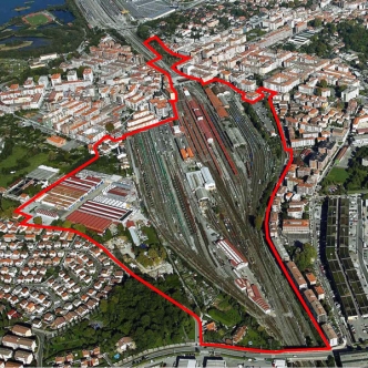
Location Railway station zone. Irun, Guipúzcoa
Population 61,847 inhab.
Project site 36.22 ha
Site proposed by Irun City Council
Owner(s) of the site Public (ADIF) and Private
Commision after competition Management of urban development project
Team representative architect - urban planner
More info
How can the site contribute to the adaptable city?
Irun's railway yards cover a large strip of land, cutting a spatial and functional gap through the central urban area, and spilling into Hendaye, across the French border. This space is crucial for the city given the enormous territorial implantation of the railway infrastructure in Irun.
Currently the two existing railway networks (owned by ADIF, ETS and Euskotren) are engaged in a process of renovation and remodelling in order to improve the standard of service for both passengers and freight in the context of the arrival of the TGV line and its Basque "Y" configuration. In this context, the new urban renewal project for the railway area is therefore viewed as a priority objective in order to improve the integration of the railway infrastructure into the urban environment, in consultation with the relevant authorities and public bodies.
City strategy
The urban strategy for the coming years is based on the following aspects:
1. The urban renewal of the railway zone on the basis of the definition of a new model that will integrate transport, urban environment and traffic policies, with a view to stimulating the recovery of urban spaces for pedestrians, cyclists and public transport.
2. The provision of new land alternatives for housing and business activities, making use of the plots still available within the town's urban fabric, helping to regenerate a degraded zone and replacing uses that may be problematic or annoying.
3. Finally, the harmonization and adaptation of the criteria for environmental protection and regulation: comprehensively protect the land zoned as undevelopable, and expand related facilities and services, i.e, parks, sports, educational, health, welfare and cultural services.
Site definition
The planning zone includes the railway area in the central part of Irun, a large swathe of land that divides the city into two, creating a deep spatial and functional split. The industrial land and apartment blocks on the western boundary of this space are also included in order to improve the integration of this space with the consolidated town.
This space primarily consists of the shunting yards and other railway facilities for which the Ministry of Development has commissioned technical and financial studies on their adaptation to future needs arising from the arrival of the TGV line to Irun, also envisaging the conversion of the current railway station into an intermodal transport station and the incorporation of the Basque Euskotren network.
The future Master Plan will define the compatibility or otherwise of each existing building and use with the envisaged plans on the basis of the Ministry of Development's technical studies on the adaptation of the railway facilities to the future requirements for this zone.
Future of the site in relation to the site family and Adaptability
The proposed urban transformation should reduce the railway's current footprint on the city, renovate the existing railway facilities, merge the Topo‐Euskotren train line with the current railway space, and give the city a new Services Centre, business activities and residential uses.
These objectives are linked to the desire to rationalise the operation of the railway zone, adapting it to the new requirements of the commuter service and the arrival of the TGV line, as described in the Protocol of Intent signed by the various public administrations.
This should significantly reduce the barrier imposed by the railway line running through the city, structuring a grid that will complement the existing urban fabric and satisfactorily resolve the road and functional connections on either side of the railway tracks and between neighbouring districts which until now have been separated physically.
Considering the new central character desired for this set of initiatives, the Master Plan is intended to ensure at least a minimum percentage of uses for business activities to facilitate the installation of retail outlets, companies, offices, hotel services and others that are compatible with a location in urban areas.
The possible location of an area envisaged for university facilities, a bus station and the conversion of the old customs house into a public service building are also considered. With regard to the latter case, an operation on the former Customs House is proposed which will permit the construction of a facade line facing the consolidated city, maintaining the top of the old emblematic building which could be used for some kind of public facility.
Lokality Europanu:
 Belgique Belgique |
| Libramont |
| Category Town planning and architecture |
| Charleroi |
| Category Town planning and architecture |
 Deutschland Deutschland |
| Marl |
| Category Urban - landscape - architectural |
| Bamberg |
| Category Urban - landscape - architectural |
| Gera |
| Category Urban - landscape - architectural |
| Schwäbisch Gmünd |
| Category Urban - landscape - architectural |
| Selb |
| Category Urban architectural |
| Ingolstadt |
| Category Urban – landscape – architectural – traffic – sociology |
| Landsberg |
| Category Urban - landscape - architectural |
| Feldafing |
| Category Urban - landscape - architectural |
 España España |
| Irun |
| Category Urban |
| Barcelona |
| Category architectural |
| A Coruña |
| Category Urban - architectural |
| Palma |
| Category Urban - architectural |
 France France |
| Bondy |
| Category Urban - architectural |
| Goussainville |
| Category Urban - architectural |
| Marne-la-Vallée |
| Category Urban - architectural |
| Saint-Brieuc |
| Category Urban - architectural |
| Metz |
| Category Urban |
| Montreuil |
| Category Urban - environmental - architectural |
| Moulins |
| Category Urban - environmental - architectural |
| La Corrèze |
| Category Urban - architectural |
| Bordeaux |
| Category Urban planning - architectural |
 Hrvatska Hrvatska |
| Zagreb |
| Category Urban - architectural |
 Italia Italia |
| Molfetta |
| Category Urban - architectural |
 Kosovo Kosovo |
| Gjakova |
| Category Urban - architectural |
 Nederland Nederland |
| Leeuwarden |
| Category strategic - urban - architectural |
| Streefkerk |
| Category urban - architectural |
 Norge Norge |
| Trondheim |
| Category urban - architectural |
| Ørsta |
| Category urban - architectural |
| Bergen |
| Category urban - architectural |
| Os |
| Category urban - architectural |
| Stavanger |
| Category urban - architectural |
 Österreich Österreich |
| St Pölten |
| Category urban - architectural |
| Wien |
| Category urban - architectural |
| Graz |
| Category architectural urban scale |
| Bruck/Mur |
| Category urban - architectural |
| Linz |
| Category urban - architectural |
 Polska Polska |
| Warszawa |
| Category Architectural - landscape |
 Portugal Portugal |
| Santo Tirso |
| Category urban - architectural |
| Barreiro |
| Category landscape - architectural |
| Azenha do Mar |
| Category urban - architectural |
 Suisse Suisse |
| Genève |
| Category urban - architectural |
 Suomi - Finland Suomi - Finland |
| Seinäjoki |
| Category urban - architectural |
| Jyväskylä |
| Category urban - architectural |
| Espoo |
| Category urban - architectural |
 Sverige Sverige |
| Nacka |
| Category urban - landscape - architectural |
| Lund |
| Category urban - landscape - architectural |